AGRO-THINK BELT
New York State
Project
Masterplan
Client
New York State
Size
420 km / 260 mi
Collaborators
Dorothy Tang Landscape Architect, eDesign Dynamics, Econsult Solutions, Elizabeth Thomas, Langan, Stuart-Lynn Company

In its prime, the Erie Canal was the center of life, commerce, and exchange – it was a vibrant public space in the heart of the cities, towns, and villages it passed through. Rather than a return to the Canal’s past, our project turns to the legacy of the Canal - the region’s post-industrial cities, its prominent educational institutions, unique landscape, and fertile agricultural soils as a starting point to build a new form of urban living. The Erie Canal should exist not simply as a historic relic, but as a productive instrument for the development of new economies, ecologies, and lifestyles. By rethinking the infrastructural function of the canal, relationships between agriculture, education, research, industry, tourism, and living are reconfigured, creating unique and productive combinations for the future of the region.

INFRASTRUCTURE: RETENTION AND STORAGE FOR THE FUTURE
As the impacts of climate change become more and more apparent, it is vital to the future of the region to anticipate the increasingly volatile weather systems and extreme weather conditions. Floods and droughts are becoming more dramatic and less predictable. By carefully adjusting the existing locks infrastructure, the canal and spaces adjacent can be designed to absorb and store excess rain and snowmelt. This effectively turns the Erie Canal into a water reservoir and source of water for irrigation or other uses, and mitigates the risks of climate change, be they droughts or floods.
This new storage system, or “Hydro Belt” operates in three conditions. First, in cities and towns, routine snow removals are reorganized to store excess snow in spaces along the canal. During warmer months, the water is treated biologically before discharge into existing water bodies. Second, where roads coincide, or run near the Canal, polluted storm run-off can be pre-treated in bio-retention ponds before entering the canal’s waterway for storage and recreation. Third, intersections with existing river corridors increase the ecological potential of this new water storage and treatment system through bio-filtration and infiltration, recharging the groundwater table. These new storage landscapes would require slight modifications to the topography surrounding the canal and increased filtration zones, creating additional spaces for recreation, tourism, and wildlife habitats along the linear corridor of the canal. The increased storage capacity of the canal can aid in mitigating floods and the dramatic damage that can follow. Developing this water conservation system now will be a valuable resource for agriculture today and future generations.

TOURISM
Tourism alone cannot regenerate Upstate New York. Tourism for the region will only flourish as a result of the introduction of new economic, agricultural, educational, and industrial ecologies. Together with this new vision of use, the Erie Canal corridor has tremendous potential for recreational tourism. The canal can be used for kayaking and canoeing, while the existing trails adjacent to the canal ways can be further developed for hiking, cross country skiing, cycling, horseback riding, running, and walking. Portions of the canal that have been paved over, filled, or forgotten should (at a minimum) be developed into recreational pathways to reconnect Albany with Buffalo to maintain the legacy of the canal even if its form and use has changed. If the economic corridors we propose above can be developed the Erie Canal trailway can be gradually realized over time from urban node to urban node in order to reinforce the Canal as a recreational corridor, an Agro-Think Belt for economic growth, and a resource for future generations.

AGRICULTURE: LOCALIZING MATERIAL FLOWS
The Erie Canal runs through the center of the Ontario Lowlands and Mohawk Valley through some of the most productive agricultural soils in New York State. The Finger Lakes Region is the center of state agriculture as a top ten national producer of cow milk, apples, grapes, onions, sweet corn, tomatoes, and maple syrup. It is the third largest wine-producing region in the United States and is a strong producer of beer and ciders. Organic farming and small to medium agricultural production is an increasingly popular and a valuable industry well suited to Upstate New York. Building on this potential, we propose a new agricultural production center - an “Agro Belt” - along the canal that works with the new urban demand for healthy, organic, and locally grown food products. We would take advantage of the recent surge of alternative food production in the region such as local breweries, artisanal cheese, or other value-added food products to further cement the circulation and demand of local agricultural products. The reconfiguration of the canal infrastructure has the potential to provide new forms of heating and cooling systems (through heat syncs and micro hydro power at lockports) that would benefit these emerging local industries. In addition, the strong agricultural expertise in the region could enable the development of efficient and sustainable bio-fuel sources. The calibration and coupling of energy, material, and waste flows would create a new model of sustainable development for the region.

INDUSTRY: CLUSTERING KNOWLEDGE & PARTNERSHIPS FOR INNOVATION
Along with the second highest population density in New York State, many world and state renowned University and post-secondary Institutions are located in the cities along the Erie Canal corridor. The SUNY system, with a major campus in Buffalo, is one of the strongest public university systems in the country, and is known for its emphasis on arts, humanities, sciences, and engineering. University of Rochester is world renowned for its Eastman School of Music, optometry, and biomedical research. Syracuse University is known for its arts, architecture, engineering, business, and management programs. In addition, while not directly on the Erie Canal (but connected to it via Cayuga Lake), Cornell University’s contributions to agriculture, engineering, hospitality, and computing complements the knowledge base and expertise of this knowledge corridor. The clustering of these institutions within the region is an important resource for the development of high-tech and innovative industries and a knowledge economy – we envision this corridor collectively as a new “Think Belt” for New York. It is vital for the region to retain the talent and attract the appropriate workforce to fuel this new economy. The presence of Rochester, Syracuse, and Cornell can be used to develop smart industries and growth of biomedical centers for regional and national health care development. Existing factories and industrial buildings could be used to engage the growing field of mass customization, 3d printing, CNC milling, and laser cutting of specialized components. Engineering and biomedical fields could collaborate in the production of mass customized prosthetic and orthotic devices to regenerate Upstate New York’s once heavy industrial economy with new smart industries. The combined effect of strong educational institutions, enhanced urban spaces, and healthy agricultural development, makes Upstate New York an attractive place to live and raise a family. Rising real estate prices in traditional metropolitan areas, such as New York and Boston, are driving start-ups and newer innovation companies to other parts of the country. These strong educational institutions will attract a qualified workforce that can take the region further in developing closer ties to the region’s capacity for smart industry and biomedical research. This becomes a catalyst for other forms of development and associated industries that builds upon the existing strengths of the region and the legacy of the Erie Canal.

Erie Canal between Syracuse and Rome
PROTOTYPES
Reimagining the Canals means thinking on two scales simultaneously. At one scale, there needs to be a broad territorial vision for the Erie Canal corridor as described in the preceding text. At the other scale, there needs to be smaller site-scale catalysts and interventions that can be realized now or in the near future to generate changes. The sites indicated here should be considered prototypes that could be deployed to several locations and other cities along the Erie Canal. In the following we propose prototypes in these locations: 1. Syracuse; 2. DeWitt; 3. Canastota; 4. Rome.
Revealing the Erie Canal (buried under Erie Boulevard) to create a new greenway
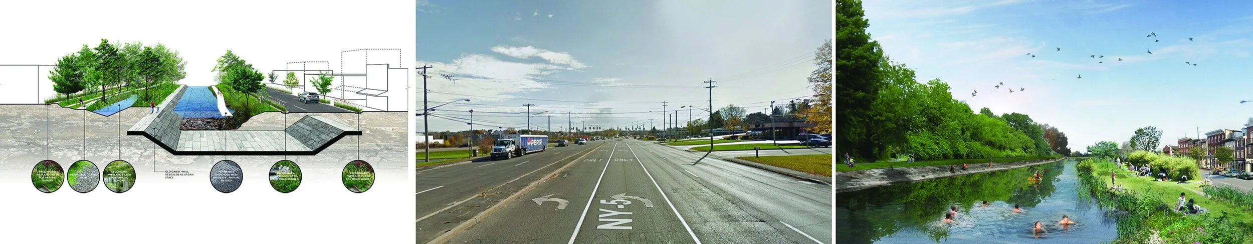
REVEALING THE CANAL BETWEEN SYRACUSE AND DEWITT
Between the City of Syracuse and Town of DeWitt the canal has been filled in and resurfaced with asphalt as Erie Boulevard, a six lane road for suburban big box retail buildings and parking lots. The boulevard is lacking sidewalks, pedestrian facilities, bus stops, and bicyle lanes. Everday, people walk the shoulderless edge of the boulevard dangerously close to traffic. Traffic studies have shown that Erie Boulevard could be reduced in width and transformed into a multimodal corridor connecting the City of Syracuse and Town of Dewitt to Erie Canal State Park at the Eastern end of Erie Boulevard.
Buried beneath this four mile stretch of Erie Boulevard lies the historic stone canal. By rerouting the freeway traffic to existing roads to the north of Erie Boulevard the boulevard’s road width can be reduced, transforming the boulevard into an extension of Erie Canal State Park to the East and connecting the State Park directly to the City of Syracuse. The addition of water and vegetation forms a park with two sides - one to the North side of the canal flush with wildlife, acting as an ecological buffer, collecting and treating road run-off from the big box retail behind - and another recreational park facing a densified urban street on the South side of the canal. Portions of the North half of the canal are excavated to the old stone canal walls forming hard urban edges for seating while the South side is cut to form a variegated wetland condition forming a diverse wetland habitat the former canal never had.

A new crossing under I-481 for people and wildlife
UNDERPASS AT ERIE CANAL STATE PARK IN DEWITT
Erie Canal State Park ends in a dead end at the intersection of Interstate 481 in DeWitt. The interstate is the most significant barrier to connecting Syracuse to Erie Canal State Park. Bridging over the highway would invariably require an ongrade crossing for pedestrians, cyclists, and horseback riders at Butternut Drive. A bridge would be costly and incur weight restrictions, limiting the people and fauna that could cross from Erie Canal State Park. Therefore, we propose an underpass that would create a new type of space in the park - a dramatic gateway that follows the exact path of the former canal, seamlessly joining Erie Canal State Park with a new Park at Towpath Road and Erie Boulevard. As a cut in the landscape connected to the ground it would create new habitats and a seamless connection between the park and pedestrian areas in DeWitt without affecting the Interstate. The areas surrounding the pathway can be used to collect Interstate water runoff, and pretreating it before it enters the parks waterways. Large light wells in the medians would create dramatic daylighting conditions along the underpass for pedestrians, cyclists, and horesback riders, while following the path of the old canal and memorializing its former presence with a new use.

A new town square for Canastota, focused around the canal
URBAN SQUARE IN CANASTOTA
For the urban square prototype, we propose a site in Canastota through which the Erie Canal runs. In the center of the town lies a number of small businesses: two banks, a canal museum, a post office, and Onieda Indian Nation, and Erie Canal Brewing. The buildings are currently oriented around parking lots that cover a small filled and paved stretch of the Erie Canal. Through planning adjustments, these businesses could be re-oriented around an urban square instead of parking lots. The square can celebrate the presence of Erie Canal Brewing as a growing local agricultural business. At harvest times, the square might be filled with grain and hops coming in from surrounding fields or beer tasting fesitvals for Oktoberfest; utilizing the presence of Erie Canal Brewing company to help revitalize the the town of Canastota. Kayakers and canoeists can use Canastota as a starting point, and encourage recreational outfitters to set up a business in town and build a boat house. In the winter, the canal can be used for ice-skating or cross-country skiing. Residential apartments could be built above the businesses around a new town center while introducing seating, street trees, and developing a urban square that celebrates the presence of the canal and the adjacent buisnesses. The canal crossing below the town square can be improved to retain water during floods and store it for drought periods. The flow of the canal can be improved to enhance the water quality and introduce fishing.

Transforming the current roadway into a ecological multi-mode greenway and reduced-width roadway in Rome
ROADWAY TRANSFORMATION IN ROME
For the roadway transformation prototype, we propose renovating Erie Boulevard West and its connection to Wood Creek (the Erie Canal) in the City of Rome. To realize the Erie Canal as a performative water retention, storage, and irrigation device a number of small scale sectional changes can be made while making simple improvements: sidewalks and bike paths to reconnect the Erie Canal with the City. In this case a path is built adjacent to the canal where it enters and leaves the city. Erie Boulevard West is narrowed while pedestrian and cycling paths are installed with rain gardens to absorba adjacent road runoff. Ideally, and depending on its precise location, the surface of the old canal can be revealed as the pedestrian walkway. The rain gardens pretreat the storm water prior to collecting and depositing it in an underground reservoir for the city’s use during storm and drought periods. Excess water can be expelled into the former canal at either end of the storage pipe or reservoir. This condition is economically inexpensive and can have a long term benefit in mitigating floods or storing water for irrigation for many cities along the Erie Canal. Traffic calming and road crossing measures can also be integrated with the overall water and pathway proposal.